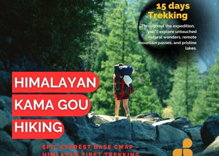
Mount Everest East Slope Base Camp Gamagou Trekking Route
Conquering the East Slope of Mount Everest: A Trekker’s Ultimate Challenge
Embark on an unforgettable 8-day trekking experience on the east slope of Mount Everest, beginning in Qudang Township, Dingri County. This challenging route, suitable only for experienced hikers, takes you through the breathtaking Gamagou Valley, nestled between Dingri County and Dingjie County in Tibet’s Xigaze Region. With elevations ranging from 2,000 to 5,000 meters, Gamagou boasts the largest and best-preserved virgin forest in the Everest region and offers a rare glimpse into an untouched ecosystem.
Highlights of the Trek
- Unique Ecosystems: Witness the diverse flora of the region, including alpine rhododendrons, as you hike through different ecological zones.
- Stunning Mountain Views: Enjoy unparalleled views of Mount Everest, along with Lhotse and Makalu, the world’s fourth and fifth highest peaks, respectively.
- Remote and Pristine: With limited access, Gamagou remains one of the most exquisite and unspoiled valleys, offering serene landscapes far from the hustle of city life.
- Yak Transport: Embrace the traditional mode of transportation as yaks carry your luggage, adding to the authenticity of your Himalayan adventure.
Gamagou Mount Everest east slope base camp hiking scenery
Mount Everest East Slope Base Camp Gamagou hiking is suitable for the crowd
The trekking route on the east slope of Mount Everest is challenging due to its complexity, significant altitude difference, changeable road conditions, and lengthy duration. The entire journey requires a minimum of 8 days. Therefore, it is only suitable for experienced hikers seeking a challenge. If you lack experience in high-altitude trekking or long-distance treks, it is advisable to avoid attempting the trek on the east slope of Mount Everest Base Camp.
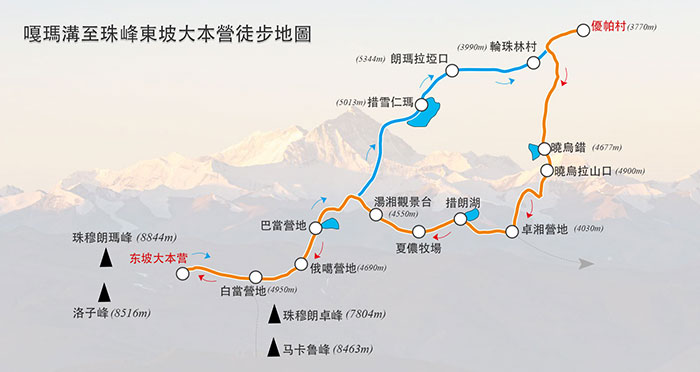
Mount Everest East Slope Base Camp Gamagou Trekking Mileage and Itinerary
The east slope of Mount Everest is a renowned high-altitude trail in China. Despite the unpredictable climate and challenging terrain, the scenery is awe-inspiring. Along the route, you can witness Mount Everest (8844.43 meters), the world’s highest peak, as well as the fourth-highest peak, Lhotse (8516 meters), and the fifth-highest peak, Makalu (8485 meters). This region is often referred to as the kingdom of snow mountains, boasting the exquisite beauty of Mount Everest.
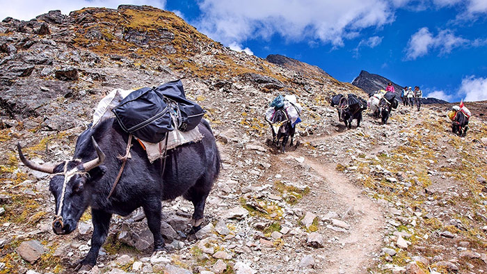
Gamagou Mount Everest East Slope Base Camp requires yaks and camels to carry luggage
Conquer the East Slope of Mount Everest: A Detailed Trekking Itinerary
Embarking on the trek to the east slope of Mount Everest Base Camp is an adventure of a lifetime. This journey, challenging yet rewarding, reveals the untouched splendour of the world’s tallest peak. Here’s a comprehensive guide to help you navigate this remarkable trek, complete with a detailed itinerary, equipment essentials, and helpful tips.
Day 1: Lhasa – A Day of Acclimatization and Welcome
- Location: Gather in Lhasa, the starting point of your adventure.
- Activities: Enjoy some free time exploring the vibrant city.
- Dinner: Partake in a welcoming banquet, an introduction to Tibetan cuisine.
- Accommodation: Stay in a standard room for a comfortable night’s rest.
Day 2: Lhasa to Qudang – A Journey through the Himalayan Vistas
- Route: An early start to the day, travelling via Shigatse, passing through the Jiawu La Pass and Tashizong, and arriving at Qudang Township by evening.
- Scenery: Witness the breathtaking scenery along the G318 and Gawula Mountain. A highlight of the day is the view from Gawula, offering a rare sight of five 8,000-meter snow-capped peaks simultaneously, including Makalu, Lhotse, Everest, Zhuao You Peak, and Shishapangma.
- Meals: The day includes simple meals to suit the journey.
- Accommodation: Rest in a comfortable bed set up, preparing for the trek ahead.
Day 3: Trek from Xiaowu Co to Zhuoxiang – The Beginning of the Hike
- Starting Point: The trek begins at Xiaowucuo (4670m), marking the first day of the hike.
- Hiking Details: Cover a distance of 10km in approximately 7-8 hours with a cumulative climb of 870 meters. The journey takes you up the river valley, focusing on acclimatization.
- Highlights: Xiaowucuo, the first lake on this trip, offers excellent photographic opportunities with its stunning location and views.
- Meals: Start with a light breakfast, followed by a road meal for lunch, and end the day with a camp meal.
- Accommodation: Camp by the lake, immersing yourself in the serene natural surroundings.
This three-day itinerary offers a blend of cultural immersion in Lhasa and the commencement of an exhilarating trek through some of the world’s most majestic landscapes. Prepare for a journey that combines physical challenges, breathtaking scenery, and an introduction to the rich Tibetan heritage.
Day 2: Xiaowu Co to Xiaowula to Xueruo River Valley to Zhuoxiang
- Starting Point: Xiaowucuo.
- Destination: Zhuoxiang via Xiaowula Pass.
- Altitude Range: 4,650 meters (Xiaowucuo) to 4,900 meters (Xiaowula Pass) to 4,000 meters (Zhuoxiang).
- Hiking Distance: 9 kilometers.
- Time Taken: Approximately 6-7 hours.
- Cumulative Climb: 200 meters (ascent to Xiaowula Pass).
- Cumulative Descent: 950 meters (descent to Zhuoxiang).
- Main Attractions:
- Reflections of snow-capped mountains (Makalu, Everest) in Xueruo River Valley.
- Scenic views of Karma Zangbo.
- Rich vegetation in Xueruo Valley and Zhuoxiang.
- Meals: Camp meal for breakfast, road meal for lunch, camp meal for dinner.
- Accommodation: Camping.
Day 3: Zhuoxiang to Tangxiang
- Starting Altitude: 4,000 meters (Zhuoxiang).
- Route: Zhuoxiang → Colang → Xia Nong Ranch → Tangxiang.
- Altitude Progression:
- Colang: 4,320 meters.
- Xia Nong Ranch: 4,400 meters.
- Tangxiang: 4,550 meters.
- Hiking Time: 6-7 hours.
- Scenery: Ever-changing landscapes throughout the trek.
- Meals: Camp meal for breakfast, road meal for lunch, camp meal for dinner.
- Accommodation: Camping.
Day 4: Tangxiang to Okay via Badang
- Starting Altitude: 4,550 meters (Tangxiang).
- Route: Tangxiang → Badang → Okay.
- Altitude Progression:
- Badang: 4,315 meters.
- Okay: 4,690 meters.
- Hiking Distance: 9 kilometers.
- Time Taken: 6-7 hours.
- Cumulative Climb: 500 meters.
- Cumulative Descent: 350 meters.
- Highlights:
- Rizhao Jinshan views.
- Overlooking Garmag Valley.
- Distant views of Everest.
- Tangxiang Platform as a notable viewpoint.
- Path Description: Descent to Rega Valley, gentle slope to Badang Pasture, and ascent along a gravel slope to Okay. Option to camp in Baidang with wider views and closer proximity to Mount Everest.
- Meals: Camp meal for breakfast, road meal for lunch, camp meal for dinner.
- Accommodation: Camping.
Day 5: Oga to Rega via Baidang
- Date: 10.2
- Route: Oga → Baidang → Rega.
- Altitude: Start at Oga, Baidang at 4,950m, end at Rega 4,200m.
- Hiking Distance: 8km.
- Time Taken: 6-7 hours.
- Cumulative Climb: 300m.
- Cumulative Descent: 750m.
- Scenery: Everest, Lhotse Peak, Garmagou.
- Meals: Camp meal (breakfast and dinner), road meal (lunch).
- Accommodation: Camping.
Day 6: Rega to Cuoxuerenma via Tangxiang Platform
- Date: 10.3
- Route: Rega → Tangxiang Platform → Cuoxuerenma.
- Altitude: Tangxiang Platform at 4,550m, Cuoxuerenma at 4,950m.
- Hiking Distance: 7km.
- Time Taken: 7-8 hours.
- Cumulative Climb: 750m.
- Scenery: Snow-capped mountain reflections including Everest, Lhotse, Makalu.
- Meals: Camp meal (breakfast and dinner), road meal (lunch).
- Accommodation: Camping.
Day 7: Cuoxuerenma to Qudang via Langmala Pass and Lunzhulin Village
- Date: 10.4
- Route: Cuoxuerenma → Langmala Pass → Lunzhulin Village → Qudang.
- Altitude: Langmala Pass at 5,344m.
- Hiking Distance: 12km.
- Time Taken: 7-8 hours.
- Cumulative Climb: 400m.
- Cumulative Descent: 1,100m.
- Scenery: Mountain lakes, views of Everest and other peaks from Langmala Pass.
- Meals: Camp meal (breakfast and dinner), road meal (lunch).
- Accommodation: Camping, with an option to stay in Qudang or return to Tingri.
Day 8: Return to Lhasa
- Date: 10.5
- Activity: Travel from Tingri to Lhasa.
- Meals: Light meals for breakfast and lunch, celebration banquet for dinner.
- Accommodation: Standard room.
Day 9: Departure from Lhasa
- Date: 10.6
- Activity: Departure from Lhasa to various destinations.
- Note: The end of a challenging and enjoyable trip.
Trekking the east slope of Mount Everest is a test of endurance and a remarkable adventure that will leave you with unforgettable memories. It’s crucial to equip yourself with camping gear, waterproof jackets, high-top hiking shoes, snow cover, sunglasses, and other essential gear to ensure your safety and comfort. Additionally, enlisting a local guide and benefiting from the assistance of yaks and their handlers will help you navigate the complex and ever-changing terrain while lightening your load. Prepare for a life-changing journey through some of the world’s most breathtaking landscapes.