The Essence of Parlung Tsangpo River
The Parlung Tsangpo River—also written as Parlung Zangbo, Polong Tsangpo, or Bo Tsangpo River—is one of the most powerful and scenic rivers in southeastern Tibet. Flowing through Nyingchi (Linzhi), mainly across Bomi County, it is the largest and most water-rich left-bank tributary of the Yarlung Tsangpo River. Its dramatic gorges, dense forests, glaciers, and legends make it a defining natural feature of the eastern Tibetan Plateau.
Originating from the southwestern foothills of the Boshula Range and the southern slopes of the Nyenchen Tanglha Mountains, the river begins at an altitude of around 4,900 meters. From there, it travels approximately 266 kilometers, draining a basin of about 28,610 square kilometers, before merging with the Yarlung Tsangpo and entering the greater canyon system downstream.
The Lore and Meaning of “Parlung Tsangpo”
The name “Parlung Tsangpo” is often translated as “Fatherland River”, rooted in a deeply moving local legend. According to oral tradition, a father and his daughter once lived in a wooden loft beside the river. The daughter, renowned for her beauty and devotion, journeyed downstream to worship the Buddha and never returned. It was said that she later married a king in a distant land.
Longing to reach her, the father sent messages sealed in bamboo tubes down the river. When these messages eventually reached his daughter, she named the river Parlung Tsangpo in remembrance of her homeland and her father. This story has become inseparable from the river’s identity, giving it emotional depth beyond its physical grandeur.
River Course and Geographic Features
From its glacial source, the Parlung Tsangpo follows a complex and ever-changing course:
- Upper Reaches (Source to Ranwu Lake):
Wide glacial valleys dominate this section, shaped by ancient ice movements and surrounded by snow peaks. - Ranwu Lake to Bomi:
The river passes through Ranwu Lake, an important natural reservoir and scenic highlight along National Highway 318. This stretch features deeply incised valleys and relatively stable flow. - Bomi to Tongmai:
The river begins to cut sharply downward, forming steep gorges and fast-flowing rapids. This area once included the infamous Tongmai “natural barrier”, a historically dangerous section of the Sichuan–Tibet Highway. - Pailong to Confluence:
Near Pailong Menba Ethnic Township, the Parlung Tsangpo makes dramatic bends before finally joining the Yarlung Tsangpo River, contributing massive water volume to the main stream and feeding into the greater canyon landscape.
With a total elevation drop of over 3,300 meters, the river’s energy shapes some of the most rugged terrain in southeastern Tibet.
Parlung Tsangpo Gorge: A World-Class Canyon
The Parlung Tsangpo Gorge stretches for more than 76 kilometers, beginning near ancient glacial debris-dammed lakes and extending through a landscape of sheer cliffs, waterfalls, and continuous rapids. On average, its depth surpasses that of both Peru’s Colca Canyon and the Grand Canyon in the United States, placing it among the deepest gorges in the world.
This canyon is famous for landmarks such as:
- Midui Glacier, a rare low-altitude marine glacier
- Ranwu Lake, reflecting snow peaks and forests
- Stepped waterfalls cascading down near-vertical rock walls
The gorge is not only a geological wonder but also a corridor of intense climatic change, where cold alpine conditions gradually shift toward humid, forested environments.
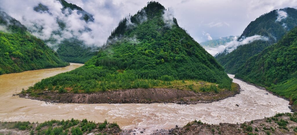
The Great Bends of Parlung Tsangpo
One of the river’s most striking features is the Great Bends of Parlung Tsangpo. Within a stretch of about 100 kilometers, the river forms three massive U-shaped bends, located near:
- Sutong Village
- Tongmai Town
- Pailong Menba Ethnic Township
At an average elevation of around 2,000 meters, these bends create the most concentrated group of large river bends yet discovered. Seen from above, the river appears to coil through the mountains like a living ribbon, producing a rare and majestic natural spectacle that draws geographers, photographers, and explorers alike.
Forest Ecology of the Parlung Tsangpo Basin (The Heart of Nyingchi)
The Parlung Tsangpo basin lies at the core of southeastern Tibet’s forest ecosystem, one of China’s three largest original forest regions. This area is often called “the Switzerland of Tibet” due to its dense coniferous forests, snow peaks, and green valleys.
Vertical Vegetation Zones
Along the riverbanks, vegetation changes dramatically with altitude:
- Alpine shrub meadows in higher elevations
- Subalpine dark conifer forests dominated by spruce and fir
- Evergreen broadleaf forests in lower, warmer valleys
This complete vertical forest belt is rare on the Tibetan Plateau and supports extraordinary biodiversity.
Gang Township Spruce Forest: A Natural Treasure
One of the most representative forest areas is the Gang Township Natural Reserve in Bomi County, located along the southern bank of the Parlung Tsangpo.
- Dominated by Linzhi spruce, mixed with fir and Chinese pine
- Tree heights reach 50–60 meters, with trunk diameters often exceeding 1–2.5 meters
- Timber volume per hectare exceeds 1,000 cubic meters, an exceptional figure even nationwide
The forest floor is rich with rhododendrons, bamboo, and mosses, creating a prime environment for wildlife and medicinal plants.
Flora, Fauna, and Medicinal Resources
The Parlung Tsangpo watershed is a true biological treasure house. Dense forests and remote valleys shelter:
- Wildlife: takin, deer, antelope, bears, leopards, and Tibetan pheasants
- Medicinal plants: gastrodia elata, notoginseng, and lingzhi mushrooms
- Rare vines, orchids, and flowering shrubs that thrive in the humid climate influenced by Indian Ocean monsoons
These forests also play a crucial role in water conservation, soil stabilization, and carbon sequestration, making them ecologically indispensable to both the Parlung Tsangpo and the Yarlung Tsangpo systems.
Hydrology and Climate Characteristics
The river is primarily fed by glacial meltwater, supplemented by heavy seasonal rainfall. Southeastern Tibet, including the Parlung Tsangpo basin, is one of the wettest regions on the plateau, thanks to warm, moist air from the Indian Ocean.
- Summer: high water levels, strong currents, higher sediment load
- Winter: relatively stable flow, clear waters
- Overall: abundant runoff, making it the most water-rich tributary of the Yarlung Tsangpo
Travel Highlights Along Parlung Tsangpo
Traveling along the Parlung Tsangpo is often described as moving through a natural scenic corridor of Nyingchi:
- Ranwu Lake: a must-stop along Highway 318
- Gang Township Spruce Forest: ideal for hiking and photography
- Parlung Tsangpo Gorge viewpoints: near Pailong and Tongmai
- Tongmai Bridge: symbol of modern engineering overcoming natural barriers
- Lulang Forest and Pastures: downstream forest-meadow landscapes
The best time to visit is from May to October, when forests are lush and rivers are at their most dramatic, while autumn adds colorful foliage to the valley slopes.
Natural Power and Conservation Balance
With its steep gradient and massive runoff, the Parlung Tsangpo holds significant hydropower potential. However, due to its ecological sensitivity and protected forest zones, development remains limited. Conservation efforts, including nature reserves and controlled tourism, aim to balance infrastructure improvement with long-term environmental protection.
Frequent geological activity, including landslides and debris flows, also reminds visitors that this is a living, evolving landscape shaped by both water and mountains.
The Parlung Tsangpo River is far more than a tributary—it is a lifeline of forests, legends, and raw natural power, weaving together the geography, ecology, and cultural memory of Nyingchi and Bomi as it flows toward the heart of the Yarlung Tsangpo system.