Tibet, widely known as the “Roof of the World,” is one of the most extraordinary geographical regions on Earth. With its vast high-altitude plateau, towering mountain ranges, ancient rivers, and unique ecosystems, Tibet’s geography shapes not only its own culture and environment but also the climate and water systems of much of Asia. Stretching across immense distances and dramatic elevations, this land offers a powerful blend of raw nature, spiritual depth, and ecological significance.
Located mainly within the Tibet Autonomous Region (TAR) of China, Tibet covers approximately 1.2 million square kilometers and has an average elevation of over 4,000 meters, making it the highest inhabited region in the world. From snow-covered peaks to wide open grasslands, Tibet’s landscape is both diverse and extreme, captivating travelers, researchers, and spiritual seekers alike.
The Tibetan Plateau: The True Roof of the World
At the heart of Tibet’s geography lies the Tibetan Plateau, the largest and highest plateau on the planet. Spanning around 2.5 million square kilometers with an average elevation above 4,500 meters, it was formed by the collision of the Indian and Eurasian tectonic plates—a geological event that continues to shape Asia today.
The plateau features vast rolling plains broken by rounded mountain ranges and deep valleys. The northern region, known as the Chang Tang (Northern Plateau), is a remote and arid wilderness characterized by tundra-like grasslands, permafrost, marshy soils, and sparse vegetation. This area remains one of the least populated regions on Earth.
In contrast, the southern and eastern parts of the plateau gradually descend into more fertile river valleys. Here, richer alluvial soils support farming and permanent settlements. The Tibetan Plateau also plays a crucial role as a climatic barrier, influencing monsoon patterns and creating rain shadows that affect weather systems across South and Central Asia.
Majestic Mountain Ranges of Tibet
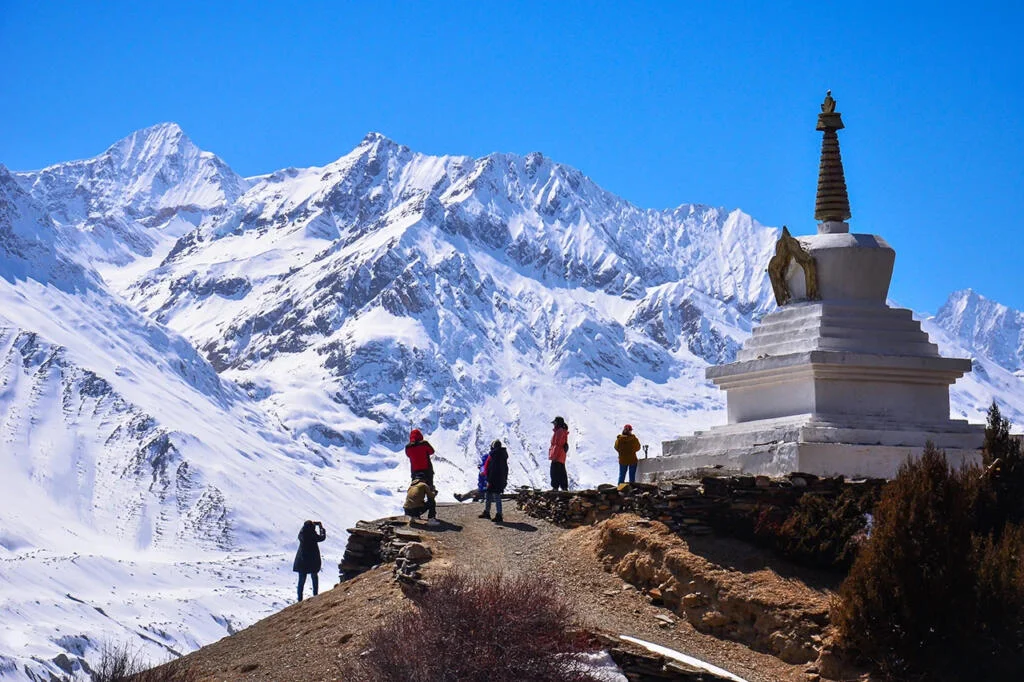
Tibet is surrounded and crossed by some of the world’s most powerful mountain systems. The most famous is the Himalayan range in southern Tibet, home to Mount Everest (Qomolangma), which rises to 8,848 meters on the Tibet–Nepal border.
Beyond the Himalayas, several other major ranges define Tibet’s rugged terrain:
- Gangdise–Nyenchenthanglha Range in central Tibet
- Karakoram Range in western Tibet
- Hengduan Mountains in eastern Tibet, where dramatic gorges and forested slopes dominate
Peaks like Namcha Barwa (7,782 meters) mark the eastern end of the Himalayas and are surrounded by some of the deepest valleys on Earth. These mountains feature glaciers, steep cliffs, and historic high passes such as North Col and Cherko La, once vital trade and pilgrimage routes. Today, they attract mountaineers, trekkers, and adventure travelers from around the world.
Rivers and Lakes: The Lifelines of Asia
Tibet is often called the “Water Tower of Asia” because many of the continent’s greatest rivers originate here. Fed by glaciers and high-altitude snowmelt, these rivers sustain billions of people downstream.
The most significant river is the Yarlung Tsangpo, the upper course of the Brahmaputra River. It carves the Yarlung Tsangpo Grand Canyon, the deepest canyon in the world, plunging more than 5,000 meters near Namcha Barwa.
Other major rivers rising in Tibet include:
- Indus River
- Mekong (Lancang)
- Salween (Nu River)
- Yangtze River
- Yellow River
Tibet is also rich in lakes, especially in the western Lake Region. Many of these lakes are saline and have no outlet. Notable examples include:
- Nam Co – the largest lake in Tibet, at 4,718 meters
- Yamdrok Lake – one of Tibet’s three sacred lakes
- Lake Manasarovar – a sacred pilgrimage site near Mount Kailash
- Pangong Tso – famous for its changing blue hues
These lakes are not only ecological hubs but also hold deep spiritual meaning in Tibetan culture. Hot springs and geothermal areas further highlight Tibet’s dynamic geological nature.
Climate and Weather Patterns in Tibet
Tibet’s climate is generally cold and dry, shaped by its extreme altitude. Most regions experience an alpine climate, with conditions ranging from subtropical highland in the southeast to arid desert in the northwest.
Annual precipitation is relatively low, averaging 100–500 millimeters, with most rainfall occurring during summer due to weak monsoon influences. Temperature variations are dramatic—summer daytime temperatures may reach 24°C, while nights often fall below freezing.
Winters are especially harsh in the Chang Tang, where temperatures can drop below -20°C. Eastern Tibet receives more moisture, allowing forests to grow, while central and western Tibet remain dry and windswept. Despite the cold, Tibet enjoys abundant sunshine, often exceeding 3,000 hours per year, earning it the nickname “Land of Sunshine.”
Biodiversity: Life at High Altitude
Despite its harsh environment, Tibet supports remarkable biodiversity. Vegetation ranges from dense forests and alpine meadows in eastern Tibet to sparse grasslands and shrubs in the west. River valleys sustain crops such as barley, a staple of Tibetan life.
Wildlife found on the plateau includes:
- Snow leopard
- Tibetan antelope (chiru)
- Wild yak
- Tibetan blue bear
- Black-necked crane, a sacred bird in Tibetan culture
Protected areas like the Chang Tang Nature Reserve help preserve these fragile ecosystems, which are specially adapted to high altitude and extreme weather conditions.
Environmental Challenges and Conservation Efforts
Tibet faces growing environmental challenges. Climate change is causing glaciers to retreat at alarming rates, leading to expanding lakes, increased flood risks, and long-term concerns over water availability for Asia’s major rivers. Desertification, overgrazing, and mining further strain the fragile landscape.
To address these issues, conservation initiatives focus on expanding nature reserves, promoting sustainable tourism, and protecting wildlife habitats. Preserving Tibet’s environment is critical not only for local communities but also for the ecological balance of much of Asia.
Human Geography and Settlements
Human settlement in Tibet is closely tied to geography. Most towns and cities are found in fertile river valleys, especially along the Yarlung Tsangpo River. Major urban centers include Lhasa, Shigatse, and Gyantse, where agriculture, trade, and religious life converge.
In contrast, the lake regions and northern plateau are dominated by nomadic pastoralism, with herders raising yaks and sheep across vast grasslands. Tibet’s geography has deeply influenced its culture, from monastery locations on sacred mountains to architectural and lifestyle adaptations for high-altitude living.