Lhasa, the capital of Tibet, is renowned for its spiritual heritage, iconic palaces, and vibrant culture. Yet beyond the Potala Palace and Jokhang Temple lies a natural gem that blends urban life with highland beauty—the Lhasa River Scenic Belt. Stretching through the heart of the city, the Lhasa River, or Jiqu (“Happy Water” in Tibetan), is the largest tributary of the Yarlung Tsangpo River. Its serene waters, lush banks, and carefully designed ecological spaces make it a must-visit destination for both locals and travelers seeking a harmonious mix of nature, culture, and recreation.
This guide provides an in-depth look at the Lhasa River, highlighting its natural landscapes, seasonal beauty, attractions, and activities, along with practical travel tips for an unforgettable experience.

Overview of the Lhasa River
The Lhasa River stretches approximately 560 kilometers and drains a vast area of about 32,000 square kilometers. Originating in the Nyenchen Tanglha Mountains, it flows across Lhasa city and eventually joins the Yarlung Tsangpo River in Qüxü County. The river’s urban segment, roughly 20 kilometers long, has been carefully preserved as an ecological corridor that connects both riverbanks. This “one river, two banks” approach ensures that the cityscape coexists harmoniously with nature, offering stunning views, recreational spaces, and wildlife habitats.
The Lhasa River Scenic Belt exemplifies Tibet’s vision of sustainable urban development, combining ecological protection with public enjoyment. Visitors can enjoy clear waters, green shores, cultural landmarks, and recreational facilities all in one setting.
Key Scenic Areas Along the Lhasa River
1. Urban Core: Chengguan District
The urban section of the river, particularly in Chengguan District, is the centerpiece of the Lhasa River Scenic Belt. Here, several unique spaces allow visitors to experience the river up close.
- Two-Island Green Corridor
Located between Xianzu and Taiyang Islands, this 4.1 km stretch forms a natural and cultural oasis in the city. It includes 35,000 m² of ecological space, preserves 1,452 native trees, and adds 70,000 m² of new greenery. The layout is designed as “river within islands, islands within river,” offering a unique and tranquil landscape perfect for photography, walks, and nature observation. - Binhe Park
Covering 8,000 m² with 5,000 m² of water area, Binhe Park offers stunning views of the Potala Palace reflected in the river. Visitors can stroll along the boardwalk, relax on benches, or enjoy the lotus sculptures and observation decks. The park also has a pier for daytime and night river cruises. - Chinese Culture Park
This park spans both sides of the Lhasa River and is connected by the 1,093-meter Hemmei Lianxin Bridge. With walking paths, fitness trails, and observation decks, the park is a popular spot for locals and tourists seeking a combination of exercise, leisure, and scenic beauty.
2. Wetlands and Ecological Zones
The Lhasa River also features important wetlands and ecological areas that serve as habitats for rare species and educational spaces for visitors.
- Laru Wetland
Known as the “lung of Lhasa,” the Laru Wetland is the highest-altitude urban natural wetland in the world. It provides shelter for black-necked cranes and other rare birds. In autumn, golden reeds create a striking contrast with the blue sky and river, offering an almost painterly landscape. - Lhasa River Wetland Park
This artificial wetland focuses on water purification and ecological education. Visitors can learn about highland wetland ecosystems through information boards while enjoying the natural beauty of the surroundings.
Seasonal Highlights
The Lhasa River’s landscape changes with the seasons, making it a year-round destination.
- Spring (April–May): As snow melts, the river waters turn clear and blue. Willows along the banks sprout fresh leaves, peach blossoms bloom, and migratory birds return, creating a lively and colorful scene.
- Summer (June–August): The river swells with emerald-green water, shaded by lush trees. Snow-capped peaks reflect in the water, and the evenings offer breathtaking sunsets—a perfect combination of mountain, river, and city views.
- Autumn (September–October): Golden poplars line the riverbanks, contrasting with the deep blue water. Photographers and tourists flock to capture the “highland autumn painting” effect.
- Winter (November–March): Water levels drop, revealing winding riverbeds. The river glistens in jewel-like blue, snow peaks rise starkly in the background, and migratory birds gather—a serene and contemplative time to visit.
Experiences Along the Lhasa River
1. Water Activities
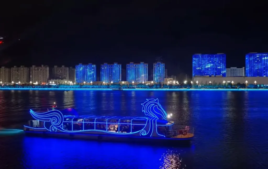
- Night Cruise: “Love Lhasa River” (launched October 2025)
A 50-minute illuminated cruise featuring themed zones: Golden Lotus Blessing, Snowy Wilderness with black-necked crane lights, Golden Bull River Meeting, Highland Sky Road, and Blossoming Gesang Flowers. The fleet includes three energy-efficient, zero-emission boats: the 28 m performance boat “Feijun,” 20 m sightseeing boat “Liangxiao Jiqu,” and 14 m tow boat “Jinniu Patrol.” - Daytime Cruise
Departing from Binhe Park Pier to Yingqin Bridge and back, the 40-minute ride costs about ¥80 in peak season. It allows close-up views of riverbanks, local wildlife, and city landmarks.
2. Walking and Cycling
- Walking
A 6 km riverside path connects Taiyang Island → Binhe Park → Lianxin Bridge → Xianzu Island. Wooden boardwalks, observation platforms, and benches make it an ideal walking route for both leisurely strolls and photography enthusiasts. - Cycling
- Popular 12 km route: Potala Palace → Norbulingka → Minzu Middle Road → Binhe Road → Chinese Culture Park → Hemmei Bridge. Offers panoramic city and river views.
- Riverside 10 km route: Lhasa Bridge → Xianzu Island → Taiyang Island → Liuwu Bridge. Multiple rest areas and viewing platforms are available, with clear views of the Potala Palace across the river.
Practical Tips for Visitors
- Best Time to Visit: May–October, with July–September being the driest months. Winter (November–March) is ideal for birdwatching and snow landscapes.
- Transportation:
- Taxi: ¥15–25, 15–30 min to the riverbanks.
- Bus: Line 19 and Binhe Road special line, ¥1–2.
- Bike Rental: ¥50–100/day; shared bikes cover main routes.
- Entrance Fees: Walking paths and observation decks are free. Paid attractions include boat tours and wetland parks.
Cultural and Ecological Significance
The Lhasa River Scenic Belt is more than a recreational area—it reflects a balance between urban development and environmental stewardship. It preserves natural habitats, provides public green spaces, and promotes eco-tourism. The river also connects Lhasa’s cultural landmarks, offering travelers an integrated experience of Tibetan history, urban life, and nature.
From the reflections of the Potala Palace in the river to the rare migratory birds of the wetlands, the Lhasa River Scenic Belt offers a unique opportunity to witness how a high-altitude city can harmoniously coexist with its natural environment.
Summary
The Lhasa River Scenic Belt is a remarkable combination of clear waters, green banks, cultural landmarks, and recreational spaces. Whether you’re strolling along its paths, cycling beside the river, or enjoying a night cruise, the scenery offers a rare blend of city and nature. Visitors can enjoy seasonal transformations, rich ecological zones, and vibrant cultural experiences—all within the heart of Lhasa.
With its mix of scenic beauty, ecological significance, and leisure activities, the Lhasa River Scenic Belt has rightfully earned its place as Lhasa’s “urban living room,” attracting both residents and travelers seeking a tranquil yet engaging highland experience.