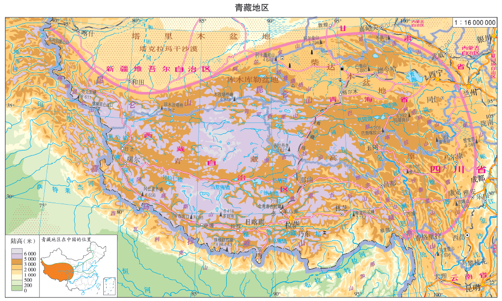
The Qinghai-Tibet region is a geographical wonder nestled in the eastern hemisphere, within the middle and low latitudes of the northern hemisphere. Situated between 73°E and 104°E longitude and 28°N to 38°N latitude, this region primarily encompasses alpine areas. Here, we embark on a journey to discover the marvels of this extraordinary location.
Location Insights
A World Within Asia
This region is strategically placed inside Asia, close to the Indian Ocean. It’s not just a part of China; it’s a distinct and exceptional entity in its own right.
Relative Placement
Stretching across the southwestern part of China, it borders the Hengduan Mountains to the east, the Kunlun Mountains, Altun Mountains, and Qilian Mountains to the south, and the Himalayas to the north. This region is a geographical crossroads, sharing its borders with some of the world’s most imposing mountain ranges.
Geographic Scope
The Qinghai-Tibet region encompasses Qinghai Province, Tibet Autonomous Region, western Sichuan, southwestern Gansu, southern Xinjiang, and the northern edges of Yunnan. Its vast expanse and diverse terrain make it a treasure trove of natural wonders.
Terrain Features
Roof of the World
This region predominantly features plateaus, with the Qinghai-Tibet Plateau being the highest and youngest in the world. The north and south are dominated by east-west running mountain ranges, while the northwest boasts a relatively complete plateau. In contrast, the northeast is home to the Qaidam Basin, and the southeast houses a north-south alpine valley.
Varied Terrain
The overall terrain stands high, with an average altitude of over 4,000 meters. Remarkably, it hosts nearly all of the world’s peaks surpassing 8,000 meters. Notably, Mount Everest, situated on the China-Nepal border, stands as the highest peak of the Himalayas, with an astounding altitude of 8,844.43 meters. This region is a testament to the ever-changing forces of nature.
Climate Wonders
Alpine Cold and More
The Qinghai-Tibet Plateau experiences a unique alpine climate due to its high terrain. The annual temperature variation is minimal, but daily temperatures exhibit significant fluctuations.
Large Diurnal Changes
The thin atmosphere at high altitudes leads to significant diurnal temperature shifts. Days are characterized by intense solar radiation, causing rapid temperature increases. Conversely, nights cool swiftly as the atmosphere struggles to retain heat, resulting in substantial temperature differences throughout the day.
Small Annual Variations
Despite its high altitude, the Qinghai-Tibet Plateau remains relatively cool during the summer. In contrast, winter benefits from abundant sunlight, as the plateau’s thin atmosphere allows for stronger solar radiation. As a result, this region maintains a milder winter compared to many other areas, including the northeastern part of China.
Abundant Sunshine
The high altitude and thin atmosphere in the Qinghai-Tibet Plateau enable strong solar radiation, providing ample sunshine. This unique combination of geographical features results in an environment that stands apart from any other in the world.
Climate and Precipitation
Unpredictable Precipitation
In this region, precipitation exhibits an uneven distribution throughout the year, characterized by distinct dry and wet seasons. The rainy season occurs from April to September annually, with precipitation gradually diminishing from the southeast to the interior of the northwest plateau. This pattern is influenced by both the southwest monsoon and the region’s topography. Conversely, the dry season spans from October to March of the following year, with precipitation levels dropping significantly, accounting for less than 1% of the annual total.
Rivers: The Lifeblood of Asia
The melted ice and snow in the Qinghai-Tibet Region serve as the source for numerous renowned rivers in Asia. Iconic waterways such as the Yangtze River, Yellow River, Lancang River (Mekong River), Nu River (Salween River), and Brahmaputra River (Brahmaputra River) all originate from this region. These mighty rivers flow through dramatic canyons within the mountainous terrain surrounding the Qinghai-Tibet Plateau. Their swift currents, significant drops, and abundant hydraulic resources play pivotal roles in the ecosystems and livelihoods of millions.
Lakes: Jewels of the Plateau
The Qinghai-Tibet Plateau boasts the highest concentration of lakes in the country, covering over 45% of the total lake area in China. Notable lakes in the region include Qinghai Lake, Namtso, Selin Co, Zhari Nam Co, Dangra Yum Co, Yangtze Lake, Zhuoyongcuo, and more. Most of these lakes sit at altitudes exceeding 4,000 meters, making them the highest lake areas on Earth. While Eling Lake and Zhaling Lake in the eastern region are freshwater outflow lakes, the majority of lakes in the Qiangtang Plateau are inland saltwater lakes and salt lakes.
Inland lakes serve as the initial stage in the formation of saltwater lakes. These lakes, where runoff flows in but doesn’t flow out, accumulate salt over time. The Qinghai-Tibet Plateau’s year-round low temperatures, limited rainfall, intense sunlight, and restricted water circulation accelerate the evolution of these lakes into saltwater bodies. Qinghai Lake, the largest in the country, becomes a temporary habitat for migratory birds during spring and summer, earning its nickname, “Bird Island.” Namtso, the world’s highest-altitude lake, holds sacred significance in Tibetan culture. Both of these lakes, like many in the region, are saltwater lakes.
Diverse Vegetation
The Qinghai-Tibet Region showcases a remarkable diversity of vegetation influenced by both horizontal and vertical differentiation.
Vegetation
| Differentiation | Performance | Reason |
|---|---|---|
| Horizontal Differentiation | The southeast experiences a warm and humid climate, while the northwest is characterized by cold and arid conditions. Vegetation patterns unfold from southeast to northwest, progressing from mountain forests to alpine grasslands, alpine meadows, and eventually alpine deserts. | The terrain mirrors this transition, with lower elevations in the southeast and higher elevations in the northwest. The north-south alignment of mountains impacts the region’s weather patterns, with the southwest monsoon bringing moisture from the Indian and Pacific Oceans during the summer half of the year. |
| Vertical Differentiation | As altitude increases, the natural landscape undergoes significant transformations. Moving from the plateau’s edge to its interior, the vertical changes shift from complexity to simplicity. | The relative height of the plateau’s edge is substantial, leading to significant variations in hydrothermal conditions with altitude. In contrast, the interior of the plateau experiences smaller relative height differences and more stable hydrothermal conditions across various altitudes. |
Soil Types in the Alpine Environment
The unique alpine environment of the Qinghai-Tibet Plateau is characterized by widespread frozen soil. Predominantly, the soil types in this region include cold desert soil and mountain meadow soil. These soil compositions are a testament to the extreme conditions and challenging terrain that define this remarkable geographic wonder.
In summary, the Qinghai-Tibet Region is a geographical treasure trove that showcases nature’s most extraordinary facets, from dramatic climate patterns to the origin of Asia’s iconic rivers, the splendor of its lakes, the diversity of its vegetation, and the unique soil types that define its alpine environment.
Bountiful Resources
1. Abundant Solar Energy
The Qinghai-Tibet Region enjoys a surplus of solar energy resources, with approximately 1,000 more annual sunshine hours compared to areas at the same latitude in the east. Lhasa, Tibet, particularly stands out as the “Sunlight City” with over 3,000 hours of sunshine annually. This abundance of sunlight is attributed to the region’s low latitude and the high angle of the sun at noon. Additionally, the high altitude, thin atmosphere, and frequent sunny days contribute to a weakened effect on solar radiation.
2. Rich Geothermal Reserves
Situated near the convergence of the Eurasian and Indian Ocean plates, the Qinghai-Tibet Region experiences geological activity that results in numerous hot springs, springs, and boiling springs. This area is endowed with a wealth of geothermal resources. Notably, southern Tibet, within the Brahmaputra Valley, boasts significant geothermal resources and is home to the largest geothermal power station in the country, the Yangpajing geothermal power station.
3. Abundant Wind Energy
The region is characterized by abundant wind energy potential, thanks in part to its high altitude and relatively flat terrain. These conditions create an ideal environment for harnessing wind power, offering vast opportunities for renewable energy generation.
4. Rich Water Energy
Abundant water energy resources are a significant asset of the Qinghai-Tibet Region, primarily concentrated in two key areas. The great bend of the Yarlung Zangbo River in southern Tibet and the upper reaches of the Yellow River in Qinghai are rich in water energy resources. The upper reaches of the Yellow River have undergone extensive development, including the construction of major power stations like Longyang Gorge.
5. Abundant Mineral Resources
The Qaidam Basin in the Qinghai-Tibet Region is renowned as a “treasure basin” due to its rich mineral resources. Here are some of the key mineral resources found in the region:
| Mineral | Distribuution | Details |
|---|---|---|
| Oil | Cold lake | In 2011, China discovered the largest inland Dongping Niudong bedrock gas reservoir near the Altyn Mountains around Lenghu. This significant find marked a substantial addition to the country’s energy resources. |
| Lead zinc | Xiti Mountain | Xiti Mountain in the region boasts a wealth of non-ferrous metals, including lead, zinc, tin, copper, gold, silver, antimony, molybdenum, germanium, and gallium. Among these, lead and zinc reserves are particularly significant, with millions of tons and high-grade deposits, averaging over 25%. |
| Lead-zinc | Qarhan Salt Lake | Qarhan Salt Lake stands as China’s largest potassium and magnesium salt deposit, boasting total reserves of various salts exceeding 60 billion tons. It produces over 4 million tons of potassium fertilizer annually. The lake is home to Qinghai Salt Lake Potash Co., Ltd., the country’s largest potash fertilizer enterprise. |
| Rock salt | Chaka Salt Lake | Chaka Salt Lake is renowned for its “Da Qing Salt.” With large, pure salt grains and a mellow taste, it is an ideal edible salt. However, it should not be consumed directly. |
These abundant resources contribute to the region’s unique economic and ecological significance, making the Qinghai-Tibet Region not only a geographic marvel but also a treasure trove of natural wealth.
Agriculture
Conditions for Agriculture
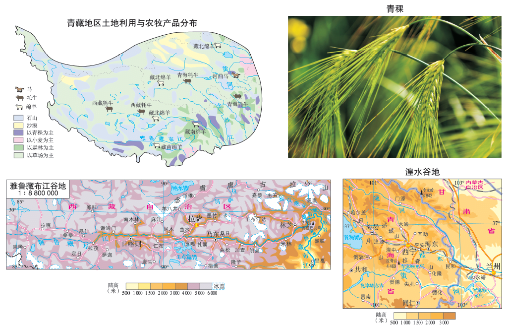
(1) Conditions
| Condition | Performance |
|---|---|
| Favorable Conditions | The region benefits from strong solar radiation, long sunshine hours, and significant temperature differences between day and night. |
| Valley areas, such as those along the Yellow River, Huangshui River, and Yarlung Zangbo River, have higher accumulated temperatures and access to water for irrigation. | |
| Vast Pasturelands | |
| The Qaidam Basin boasts extensive wastelands suitable for agriculture. | |
| Unfavorable Conditions | However, certain challenges exist, including high altitudes, low temperatures, a short frost-free period, and insufficient heat. |
Types of Agriculture
Alpine Pastoral Areas
In the alpine pastoral areas, livestock such as yaks, Tibetan goats, and Tibetan sheep thrive despite the high altitudes, cold temperatures, hypoxia, and low atmospheric pressure.
River Valley Agricultural Areas
River valley agriculture is primarily distributed in the Yarlung Zangbo River Valley and Yellow River Valley. These areas offer favourable conditions with low-lying terrain, relatively abundant heat, and significant temperature variations between day and night. These conditions promote the accumulation of organic matter and nutrients in the soil.
Additionally, the low temperatures in these areas result in longer crop growth cycles, fewer pests and diseases, and high-quality produce. The relatively flat terrain along river valleys is also conducive to farming, and the availability of water resources enhances agricultural productivity.
Crops cultivated in these regions include highland barley, wheat, peas, and more, adapted to the specific climatic and geographical conditions.
Industrial Characteristics
Outstanding Features
The industrial foundation in the Qinghai-Tibet Region is relatively weak. However, the region has a notable presence in the livestock product processing industry and mining industry within the country.
Important Industrial Cities and Zones
Key industrial cities and zones in the region include Xining (known for wool spinning), Lhasa (noted for leather and blankets), and Linzhi (recognized for wool spinning).
Transportation
Transportation Challenges
Transportation in the Qinghai-Tibet Region faces significant challenges due to its lofty terrain. High mountains, deep valleys, frozen soils, and fragile ecosystems create obstacles to transportation infrastructure development.
Main Modes of Transportation
Highways
Highways play a crucial role in the region’s transportation network. Lhasa serves as the central transportation hub, with trunk highways such as Sichuan-Tibet, Yunnan-Tibet, Qinghai-Tibet, Xinjiang-Tibet, and China-Nepal highways connecting various counties and regions. Most counties now have road access, facilitating connectivity.
Railways
Railway networks are particularly vital in Qinghai. Notable railways include the Lanzhou-Qinghai Railway, Qinghai-Tibet Railway, and Lanzhou-Xinjiang High-speed Railway (passing through Xining). However, the challenging terrain has posed significant difficulties for transportation development, hindering local economic growth. Efforts are underway to improve railways in Tibet, including the southern section of the Qinghai-Tibet Railway (Golmud-Lhasa) and the Lhasa-Shigatse Railway, which opened in 2014 and is accessible to trains.
Qinghai-Tibet Transportation: Maintaining Frozen Soil in Roadbeds
The Qinghai-Tibet Railway faces the challenge of preserving permafrost in the “thousand-year-old permafrost” area, especially during the summer when rising temperatures can lead to the melting of frozen soil, causing roadbed instability. To address this issue, three important technical measures have been implemented:
- “Hot Rod”: Often referred to as a “refrigerator” without electricity, this method involves the installation of a row of thick metal rods, resembling guardrails, on both sides of the roadbed in frozen soil areas. These “hot rods” are positioned 2 meters apart, rising 2 meters above the road surface and penetrating 5 meters below the roadbed. The rods are hollow and closed, filled with liquid ammonia, and equipped with heat sinks on top. Liquid ammonia, with its propensity to transition into a gas, acts as a “freezer,” maintaining the roadbed’s frozen state during the summer.
- “Riprap Roadbed”: Often described as a natural “air conditioner,” this approach involves the placement of a layer of gravel with a certain thickness in the middle of the upper roadbed in frozen soil areas. The gaps between the gravel are left unfilled, allowing for airflow with the external environment. This structure functions as an “air conditioner,” ensuring that the temperature of the frozen soil layer remains relatively stable, unaffected by external temperature changes, and effectively preserving its stability.
- “Sunshade Board Roadbed”: Also known as a dry bridge, this method serves as a heat-insulating “coat.” A layer of sun-blocking plates is erected on the slope of the sunshade board roadbed to reduce the impact of solar heat on the roadbed’s temperature.
Residents
- Population: The Qinghai-Tibet Region has a sparse population, making it one of the most sparsely populated areas in China.
- Nationality: The region is home to diverse ethnic groups, including the Han, Tibetan, Hui, and more.
- Religion: Tibetan Buddhism holds significant importance in the region, with Lhasa serving as a holy place of Tibetan Buddhism, notably featuring the Potala Palace.
Three River Area
- Source of Rivers
- Water Source: The Three River area’s rivers originate from the meltwater of snow mountains and glaciers.
- Regulators: Lakes and swamps play a role in regulating the water flow in the region.
- Sources of Major Rivers: The area is the source of several major rivers, including the Yangtze River (Tuotuo River), Yellow River (KariChu), and Lancang River (Zhaqu). These rivers play a vital role in the region’s hydrology and provide essential water resources.
These measures and characteristics underscore the unique challenges and significance of the Qinghai-Tibet Region, where the preservation of the environment and infrastructure is critical for sustainable development.
Protection of the Three River Area
Importance:
- It is the world’s largest high plateau wetland.
- The area hosts the highest concentration of biodiversity at high altitudes globally.
- It serves as a crucial water conservation area in China.
Challenges:
- Soil Erosion: The region experiences severe soil erosion.
- Grassland Desertification: Grasslands are suffering from desertification.
- Pests and Rodents: Rampant pest and rodent issues.
- Wildlife Decline: A decline in wildlife populations.
Causes:
- Natural Factors: Global warming leads to the gradual shrinking of glaciers.
- Human Activities: Overgrazing and indiscriminate mining contribute to environmental degradation.
Measures Taken:
- Establishment of Sanjiangyuan (Three River Valley) Nature Reserve.
- Initiatives to Return Farmland to Grassland (and Forest).
- Implementation of a Total Hunting Ban.
- Prohibition of Alluvial Gold Mining.
- Implementation of Rest Grazing and Grassland Management.
- Execution of Natural Forest and Pasture Protection Projects.
These measures aim to address the ecological challenges faced by the Sanjiangyuan area and protect its unique biodiversity and critical role in water conservation.
Trivia Fuun Facts about Tibet
- Tibet University for Nationalities is not located in Tibet but in Xianyang, Shaanxi.
- While most Tibetans traditionally avoid eating fish,
- Sweet tea is not an ancient Tibetan tradition but was introduced to Tibet by foreigners over 200 years ago.
- Tibetans carry knives not for self-defence but because they need their cutlery when eating. Knife scabbards often have slots for chopsticks.
- Coins are rarely in circulation in Tibet due to historical reasons, including a lack of Tibetan inscriptions on coins and practical issues with carrying coins in traditional Tibetan clothing.
- The centre of Lhasa is not the Potala Palace but the Jokhang Temple.
- Tibet had its first psychiatric hospital in 2016.
- Shigatse covers the full geographical diversity of Tibet.
- Tsangyang Gyatso’s story differs from common misconceptions.
- Tibetan marriage customs are not highly patriarchal.
- Tibetans prefer odd numbers for wine and rituals.
- Cordyceps harvesting is a yearly tradition in many areas.
- Garlic is avoided by devout Tibetans due to its odour.
- Elderly Tibetans over 80 wear special symbols of the Sun and moon on their clothing.
- Tibetan New Year follows a distinct calendar and varies regionally.
- Leaving Tibet with Tibetan household registration is challenging.
- The best chilli powder in Tibet is said to be from Qamdo.
- Cement factories are prevalent in Tibet.
- Tibetans often prefer to be called “Bodpa”
- There’s a belief that not piercing ears leads to the next generation becoming donkeys.
- Potatoes are a commonly grown crop in Tibet.
- Winter vacations in Tibetan schools are longer than summer vacations.
These intriguing facts offer insights into the culture, traditions, and unique characteristics of Tibet and the Qinghai-Tibet Plateau region.