Danba (Rongzhag): the Legacy of the Gyarong Tibetans
Located along the Dadu River, Danba County—known in Tibetan as Rongzhag (རོང་བྲག) is a unique cultural and geographical crossroads on the northern Sichuan–Tibet route. Flowing through this region, the Dadu River connects with three tributaries rivers, forming one of western Sichuan’s most important waterways.
The county seat, Zhanggo Town, stretches along the river in a narrow strip of land just 2 kilometers long. At an elevation of only 1,780 meters, it is relatively low compared to most Tibetan areas, making it a rare and accessible destination.
Historically known as the “Land of a Thousand Watchtowers,” Danba is centered around the sacred Mount Murdo, with Yala Snow Mountain forming its natural boundary. Across the valleys, ancient Tibetan villages and centuries-old stone watchtowers create one of the most distinctive landscapes in the region.
Danba County Historical Timeline
The history of Danba County reflects a long process of cultural interaction, administrative change, and regional integration across different dynasties. During the Tubo (Tibetan Empire) eastward expansion, local Qiang populations mixed with Tibetan frontier soldiers and cultural elements. This ethnic integration over centuries gave rise to the distinct Gyalrong identity, language (a Qiangic branch of Tibeto-Burman), customs, and architecture.
The Gyalrong region comprised 18 kingdoms or chiefdoms ruled by local Tusi (hereditary chieftains) under the Qing dynasties. Several of these chiefdoms were centered in or near modern Danba, including Trateng, Bawam, and Geshitsa. The chieftain system originated in the Yuan Dynasty as a feudal structure. Later, it was governed by religious authorities linked to Jinchuan Monastery.
In 1746, the chieftain of Greater Jinchuan (Chuchen) attempted to unite tribes, leading to the famous Jinchuan campaign, major Qing military expeditions that suppressed the Gyalrong kingdoms after decades of warfare. These wars (lasting about 30 years in some accounts) highlighted the strategic role of watchtowers for defense.
Modern History
The region was divided into smaller administrative units following the campaigns. Danba County was formally established in 1912 during the early Republic of China. After 1949, the People’s Republic of China classified Gyalrong people as part of the broader Tibetan nationality. Today, they number in the hundreds of thousands, with distinct dialects, Bon-influenced traditions (later overlaid with Gelug Tibetan Buddhism from the 15th century), and preserved folk culture.
After 1950, Danba was incorporated into the modern administrative system, and in 1955 it became part of the Garzê Tibetan Autonomous Prefecture. Today, it remains a core settlement area of the Jiarong Tibetans and an important section of the Tibetan–Qiang–Yi cultural corridor.
Recent Administrative Adjustments
In September 2005, Zhonglu Township was renamed Dongnü Valley Township. A major administrative restructuring took place in December 2019, with the consolidation and reorganization of several townships into new towns, including Dandong Town, Donggu Town, Mordu Mountain Town, and Jiaju Town. Boundaries were adjusted to improve governance and regional coordination.
Rongzhag County Administrative Divisions
Towns (9)
| Name (English) | Simplified Chinese | Hanyu Pinyin | Tibetan |
|---|---|---|---|
| Chaggo (Zhanggu) | 章谷镇 | Zhānggǔ Zhèn | བྲག་འགོ་གྲོང་རྡལ། |
| Trateng (Badi) | 巴底镇 | Bādǐ Zhèn | བྲག་སྟེང་གྲོང་རྡལ། |
| Geshitsa | 革什扎镇 | Géshízhā Zhèn | དགེ་བཤེས་གྲྭ་གྲོང་རྡལ། |
| Donggu | 东谷镇 | Dōnggǔ Zhèn | སྟོང་དགུ་གྲོང་རྡལ། |
| Mudori (Mo’erduo) | 墨尔多山镇 | Mò’ěrduōshān Zhèn | དམུ་རྡོ་རི་གྲོང་རྡལ། |
| Gya’gyü (Jiaju) | 甲居镇 | Jiǎjū Zhèn | བརྒྱ་བརྒྱུད་གྲོང་རྡལ། |
| Guzong | 格宗镇 | Gézōng Zhèn | དགུ་རྫོང་གྲོང་རྡལ། |
| Golung (Banshanmen) | 半扇门镇 | Bànshànmén Zhèn | སྒོ་ལུང་གྲོང་རྡལ། |
| Dando (Dandong) | 丹东镇 | Dāndōng Zhèn | མདའ་མདོ་གྲོང་རྡལ། |
Townships (3)
| Name (English) | Simplified Chinese | Hanyu Pinyin | Tibetan |
|---|---|---|---|
| Bawang | 巴旺乡 | Bāwàng Xiāng | དཔའ་དབང་ཤང་། |
| Sogbo (Suopo) | 梭坡乡 | Suōpō Xiāng | སོག་པོ་ཤང་། |
| Qugsug (Taipingqiao) | 太平桥乡 | Tàipíngqiáo Xiāng | ཕྱུག་ཟུག་ཤང་། |
This evolving administrative framework reflects Danba’s transition from a frontier region under traditional systems to a modern county with structured governance.
Gyalrong Tibetans – A Unique Cultural Identity
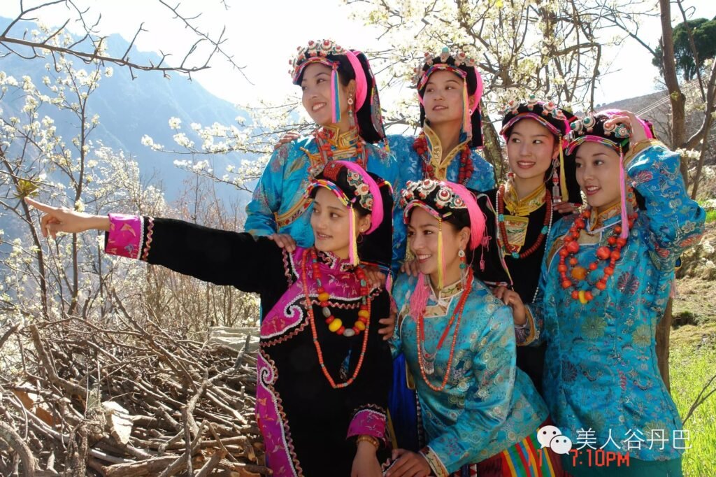
Walking through Danba, visitors quickly discover the vibrant culture of the Gyalrong Tibetans, a unique Tibetan subgroup known for their rich traditions and distinct identity. Unlike the nomadic lifestyle often associated with Tibet, the Gyalrong people have long practiced agriculture in fertile mountain valleys. Their traditional clothing is especially eye-catching—women wear black woolen garments paired with colorful embroidered aprons and headscarves, often decorated with bright patterns. A signature feature is the use of braided hair extensions to secure the headscarf, a style that has become iconic and contributes to Danba’s reputation as the “land of beautiful women.”
Danba’s cultural heritage is further reflected in its unique social customs and history. Marriage traditions often see men joining the wife’s family, with husbands sometimes taking the wife’s household name, highlighting the relatively high status of women in Gyalrong society. The region is also historically linked to the ancient Eastern Female Kingdom, with traces of matrilineal culture still visible today. In addition, many locals have traditionally followed the Bon religion, and Danba’s remote location made it an important refuge for Bon practitioners, preserving ancient spiritual traditions alongside its living culture.
Geographic Location
Danba County is located in eastern Garzê Tibetan Autonomous Prefecture along the upper reaches of the Dadu River, at the southeastern edge of the Qinghai–Tibet Plateau. It spans coordinates 101°17′–102°13′ E and 30°23′–31°29′ N, covering an area of 5,649 square kilometers, with a width of 86.9 km from east to west and a length of 105.7 km from north to south. The terrain features dramatic elevation changes, ranging from about 1,700 meters along the Dadu River to the 5,820-meter peak of Haizi Mountain, while the county seat, Zhanggu Town, sits at around 1,800 meters and the average elevation reaches approximately 3,760 meters.
Terrain and Climate of Danba County
Danba County features a dramatic highland landscape shaped by its position between the Daxue and Qionglai mountain ranges. The terrain rises in the west and north and gradually descends toward the east and south, creating a striking mix of high mountains and deep river valleys. Major rivers such as the Dadu River, Gesheza River, and Xiaojinchuan River converge in this region, forming one of the world’s most densely distributed alpine canyon systems. The land can be broadly divided into four types: river valleys, mid-mountain terraces, alpine meadows, and high mountain glacial zones, each contributing to Danba’s diverse natural scenery.
The climate of Danba is classified as a plateau monsoon climate with strong vertical variation, often described as “different weather within ten miles” and “four seasons on one mountain.” The average annual temperature is around 14.2°C, with temperature differences exceeding 24°C between valley floors and mountain peaks. Annual precipitation ranges from 500 to 1000 mm, and the frost-free period lasts about 281 days. Overall, the region experiences mild winters, cool summers, clear seasonal changes, and notable temperature differences between day and night.
Economy and Key Industries
Danba County’s economy in 2024 is driven primarily by the service sector, supported by industry and stabilized by agriculture. The county’s GDP reached 2.745 billion RMB, with a growth rate of 5.4% and a per capita GDP of 53,938 RMB. The industrial structure highlights this trend, with the tertiary sector contributing 63.5%, followed by the secondary sector at 23.8% and the primary sector at 12.7%, reflecting a shift toward tourism and service-based development.
Eco-tourism remains the leading industry, attracting 3.234 million visitors in 2024 and generating total revenue of 3.557 billion RMB. Popular destinations such as Jiaju Tibetan Village and Zhonglu Tibetan Village showcase the region’s unique Jiarong Tibetan culture and scenic landscapes. Alongside tourism, modern agriculture continues to grow, with specialty products like apples, morels, and fruit-vegetable production zones gaining market recognition, particularly the well-known “Meirencui” apple. Green industry is also developing steadily, focusing on clean energy, mining, and agricultural processing, supported by 27 active enterprises.
Jiaju Tibetan Village – A Living Photography Landscape
Jiaju Tibetan Village is one of the most developed and well-known attractions in Danba.
Often referred to as a “golden showcase” of Tibetan villages, Jiaju has been carefully designed with multiple viewing platforms and photography points. The houses are arranged across the hillside in a harmonious pattern, creating a visually striking scene.
Throughout the year, the village transforms with the seasons. In spring and summer, lush greenery surrounds the homes, while autumn brings layers of golden leaves. Mist often drifts through the valley, adding a dreamlike atmosphere that attracts photographers from across the region.
Zhonglu Village – Authentic Life and Scenic Views
Compared to Jiaju, Zhonglu Tibetan Village offers a more natural and less structured experience.
The village retains a strong sense of daily life, with traditional houses scattered across the slopes. One of the highlights here is the sunrise over Mount Murdo, which draws photography enthusiasts seeking dramatic light and mountain views.
Beyond the main viewpoints, fewer visitors explore the nearby stone coffin sites, ancient ruins, and remnants of the Eastern Female Kingdom, making them ideal for those looking for quieter experiences.
Suopo Village – Watchtowers of the Past
Suopo Tibetan Village is home to one of the largest clusters of ancient watchtowers in the region.
The best way to appreciate the scale of the village is from across the river, where the full panorama comes into view. Travelers driving along the road between Danba and the Dadu River can easily stop to admire the scenery without entering the site.
Morning is the best time for photography, as the village becomes backlit in the afternoon.
Dangling – Alpine Lakes and Hiking Routes
Dangling Scenic Area is famous for its untouched alpine lakes, dense forests, and dramatic mountain landscapes, making it one of the hidden gems of western Sichuan. The best time to visit is from mid to late October, when snow-capped peaks contrast beautifully with vibrant red autumn foliage. The main highlight is Hulu Lake, a stunning high-altitude lake surrounded by pristine wilderness and breathtaking scenery.
A popular hiking route starts from Dangling Village, ascending from 3,200 meters to around 4,200 meters in about four hours. Part of the journey can be done on horseback, but the final stretch requires a steep trek through forest trails. For more adventurous travelers, the route extends to higher alpine lakes, offering deeper exploration. The area is best experienced over two days, with an overnight stay near the lake, and also features natural hot springs along the trail, varying in temperature and mineral quality.
Moska Nature Reserve – A Hidden Paradise
Deep within the mountains lies Moska Nature Reserve, a remote and peaceful destination. The area is known for its untouched environment and simple local life. One of its most unique attractions is the chance to interact with Himalayan marmots, locally called “snow pigs.”
Due to the strong influence of Buddhist beliefs that discourage harming animals, these marmots are unusually friendly and often approach visitors. On sunny days, they can be seen resting on the grasslands outside the village. From late October to March, marmots hibernate, but during the rest of the year, visitors can observe and even feed them—creating a rare and memorable wildlife experience.
Mount Murdo – A Sacred Peak of Spiritual Significance
At the heart of Danba County rises Mount Murdo, a sacred mountain deeply revered across Tibetan regions. It holds profound spiritual significance, especially within the Bon tradition, and has long been a site of pilgrimage. Devotees follow specific dates determined by high lamas to undertake the ritual kora (circumambulation). The traditional pilgrimage route begins in Zhenda Township of Jinchuan County, crosses high mountain passes, and descends through Sanchagou in Taipingqiao Township of Danba, offering both a physical and spiritual journey through rugged terrain.
Mount Murdo is unique for preserving a rare coexistence of spiritual practices. Buddhist pilgrims walk clockwise around the mountain, while Bon practitioners follow a counterclockwise path, reflecting two ancient traditions sharing the same sacred landscape. This cultural contrast makes the mountain not only a place of devotion but also a living symbol of Tibet’s diverse religious heritage.
For visitors, one of the best viewpoints is the hillside behind Zhonglu Tibetan Village, especially at Viewing Platform No.1, where sunrise casts golden light over the sacred peak. About 9 kilometers along the road toward Xiaojin lies a small Murdo Temple, where locals gather annually on the 10th day of the seventh Tibetan month to celebrate the deity’s birth. While the temple itself is modest, it offers a meaningful cultural stop, and travelers can reach it easily by driving from Zhanggu Town via Yuezha.
Scenic Drive from Danba to Bamei
A Journey Through Changing Landscapes
The scenic drive from Danba to Bamei is one of the most breathtaking journeys in western Sichuan, offering constantly changing landscapes along the Sichuan–Tibet route. Starting in the lush, green valleys of Danba, the road gradually ascends into the open and sunlit plateau of Bamei, also known as Yak Valley. Along the way, travelers pass rushing rivers, forested cliffs, and traditional Tibetan villages that add a rich cultural layer to the natural beauty. Near Dingguo Mountain, a viewpoint offers sweeping views of distant snow-capped peaks, while the historic Yongzhong Zuoqinling Monastery provides a glimpse into the region’s Bon heritage.
As the journey continues, the route reveals unique natural highlights, including a striking red stone beach and small wild hot springs where travelers can pause and relax. Climbing higher along winding mountain roads, the landscape opens dramatically, and near the Erdaoban section, the sharp peak of Yala Snow Mountain suddenly appears in the distance. From this point onward, the scenery transforms into vast highland terrain, marking the transition from valley landscapes to the expansive Tibetan plateau.