Mila Pass : The Sacred Gateway Between Lhasa and Nyingchi
Kongpo Mila Pass, also known as Menshong La, or Kongpo Bala Pass, is one of the most important and awe-inspiring mountain passes in Tibet. Rising to an elevation of 5,013 meters above sea level, it marks the natural boundary between Lhasa and Nyingchi, and serves as a dramatic transition point between two completely different landscapes, climates, and cultural zones.
Located along the legendary G318 Sichuan–Tibet Highway, Mila Pass is not only a key transportation corridor but also a deeply revered spiritual and geographical landmark on the Tibetan Plateau.
Quick Facts About Mila Pass (米拉山口)
| Item | Details |
|---|---|
| Standard Name | Mila Pass (Mangxiong La / Jiage Jiangzong / Gongbu Bala Pass) |
| Elevation | 5,013 meters (often marked as 5,018–5,020 m) |
| Location | Border of Maizhokunggar County (Lhasa) and Gongbu Jangda County (Nyingchi), Tibet |
| Meaning in Tibetan | Menshong La: Red Valley Mountain Gongbu Bala: Middle Pass of Gongbu Jiage Jiangzong: Sacred Man Mountain |
| Geographic Role | Watershed between Lhasa River and Niyang River systems |
| Climate Boundary | Continental climate (Lhasa) vs. Oceanic climate (Nyingchi) |
| Opening Hours | Open all day, free admission |
| Distance | 158 km from Lhasa / 248 km from Nyingchi (Bayi Town) |
A Natural Divide Between Two Worlds
Watershed of Major Rivers
Mila Pass sits at a critical hydrological divide, separating the Lhasa River basin to the northwest and the Niyang River basin to the southeast. Both rivers eventually flow into different sections of the Yarlung Tsangpo River, shaping settlement patterns and ecosystems on either side of the mountain.
Climate and Vegetation Contrast: “One Step, Two Seasons”
One of the most fascinating features of Mila Pass is the sudden environmental change you experience when crossing it:
- West (Lhasa side): Cold, dry, and windy, with sparse vegetation and classic plateau scenery
- East (Nyingchi side): Warm, humid, and green, with forests, rivers, and fertile valleys
This sharp contrast creates the famous travel saying:
“One step across Mila Pass, and the seasons change.”
Part of the Nyenchen Tanglha Range
Mila Pass lies in the central section of the Nyenchen Tanglha Mountains, an area shaped by ancient glacial activity. Snow often remains on the peaks year-round, and traces of old glaciers can still be seen in the surrounding terrain.
A Sacred Mountain Pass in Tibetan Belief
A Place of Prayer and Pilgrimage
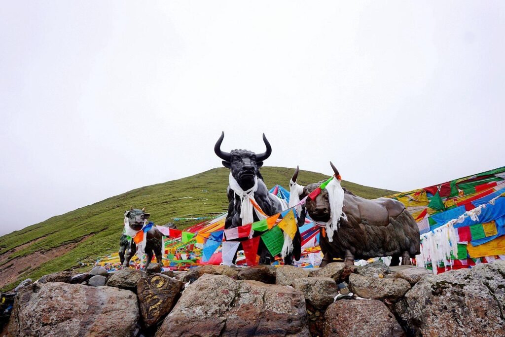
For Tibetans, Mila Pass is a holy mountain pass watched over by protective deities. At the summit, you’ll find a vast display of colorful prayer flags fluttering continuously in the wind, believed to carry prayers and blessings across the land.
The site is also an important stop on traditional pilgrimage and mountain-circumambulation routes.
Yak Stone Sculpture: Symbol of the Plateau
Standing prominently at the pass is a large yak stone sculpture, a powerful symbol of strength, endurance, and life on the Tibetan Plateau. It has become one of the most recognizable landmarks along the G318 route and a must-visit photo stop for travelers.
Highlights and Experiences at Mila Pass
Prayer Flags and Sacred Symbols
The five-colored prayer flags—blue, white, red, green, and yellow—represent sky, clouds, fire, water, and earth. Seeing them dance against the vast mountain sky is one of the most iconic visual experiences of traveling in Tibet.
Snow Mountains and Highway Views
On clear days, visitors can enjoy sweeping views of the Nyenchen Tanglha snow peaks, the winding curves of the G318 highway, and deep valleys leading toward the upper reaches of the Niyang River.
High-Altitude Nature and Wildlife
- Summer (June–August): Alpine meadows bloom with wildflowers; occasional sightings of Tibetan antelope and other plateau wildlife
- Winter (November–March): Heavy snow transforms the pass into a stark, silver-white landscape, offering a completely different but equally stunning atmosphere
Mila Mountain Tunnel: Modern Engineering vs. Ancient Landscape
Opened on April 26, 2019, the Mila Mountain Tunnel is one of the highest-altitude long highway tunnels in the world:
- Length: 5.7 km
- Entrance elevation: 4,752 m
- Exit elevation: 4,774 m
The tunnel dramatically shortens travel time and avoids the harsh weather of the pass, creating a striking contrast between modern infrastructure and timeless natural scenery.
How to Visit Mila Pass
Best Ways to Get There
Self-Drive or Private Car (Highly Recommended)
- G318 National Highway:
Cross the main Mila Pass itself, with viewing platforms and parking areas for photos and short walks. The road is fully paved but has many curves. Snow and ice are common in winter. - Lalin Expressway (Free):
Passes through the Mila Mountain Tunnel. Faster and safer in bad weather, but no stopping for views inside the tunnel.
Recommended plan:
Go via G318 over the pass for sightseeing, and return via the tunnel to save time.
Public Transportation
Most buses between Lhasa and Nyingchi use the tunnel and do not stop at the pass. Travelers who wish to visit Mila Pass should choose a tour vehicle or arrange in advance with the driver.