Biru County: The Ancient Land Between the Tanggula and Nyenchen Tanglha Mountains
Overview of Biru County (Naxiu)
Biru County (འབྲི་རུ་རྫོང་།), also known as Naxiu, is located in the northeastern part of the Tibet Autonomous Region. It lies gracefully between two of Tibet’s most powerful mountain ranges—the Tanggula Mountains to the north and the Nyenchen Tanglha Mountains to the south. The Tibetan name ’bri-ru literally means “horn of a female yak,” a reference rooted in local legends that speak of an ancient tribe known as the Dri Clan.
Biru County carries the postal code 852300 and the telephone area code 0896. Geographically, it spans latitudes 30.8°–32.2°N and longitudes 92.6°–94.4°E, placing it firmly within the vast highland heart of Northern Tibet.
In historical records, Biru has appeared under multiple names due to transliteration and dialect differences, including Nashu, Nakchu biru, Nakshu, and Shake, reflecting its long-standing presence in Tibetan history.

Geographic Location and Natural Setting
Biru County borders Bamda County and Sog County to the east, Jiali County to the south, Nagqu County to the west, and Baqing County and Nyainrong County to the north. This strategic position between major mountain systems gives Biru a strikingly diverse landscape. Biru town is located on the Gyalmo Ngulchu River (upper part of Salween River)
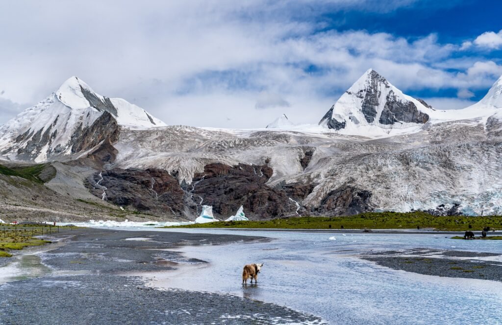
Here, travelers encounter rolling alpine meadows, deep river valleys, snow-covered peaks, and vast grasslands that stretch toward the horizon. The region’s untouched plateau environment makes Biru County an appealing destination for those interested in Tibetan geography, high-altitude ecosystems, and remote exploration.
Early History and the Subi Tribe
Biru County’s history extends back more than 2,000 years. As early as the 4th century BCE, the region formed part of one of ancient Tibet’s twelve minor kingdoms, belonging to the Subi Tribe, one of the earliest known Tibetan tribal groups.
During the 7th century, under the reign of King Songtsen Gampo (629–650 CE), the Subi tribe was unified into the expanding Tibetan Empire. At this time, Biru became part of an administrative region known as Subiru, marking its formal integration into imperial Tibet.
By the Song Dynasty (960–1279 CE), the area was commonly recorded as Naxue, while later historical documents continued to use varying names due to linguistic evolution and regional pronunciation.
Biru County in the Sakya Dynasty Postal Network
In the 13th century, during the Sakya Dynasty, Tibet came under centralized imperial administration. In 1260 CE, Sakya Yuan officials were sent to Tibet to conduct population registration and establish a postal relay system across the plateau.
A total of 27 postal relay stations were constructed throughout Tibet, with 11 located in the Ü-Tsang region. Among them, Shachüka (Lower Chuka) in today’s Biru County played a crucial role. Known at the time as Shaka, it served as a major relay station for imperial messengers, linking central Tibet with northern routes and reinforcing Biru’s importance in regional communication and trade.
Administrative History and Modern Development
In 1632, Biru County came under the direct administration of the Ganden Phodrang in Tibet. After internal unrest, governance shifted to the Kashag, Lhasa government of Tibet.
A major administrative change occurred in 1941, when the Kashag government abolished the Hor Kyichu system and established six districts (dzongs), including Biru Dzong, marking Biru’s formal recognition as a local administrative unit.
Following reforms, the People’s Government of Biru County was officially established in September 1959, initially under the Heihe Special Administrative Region. In 1960, this region was renamed Nagqu Prefecture, now known as Nagqu City.
Population, Area, and Administrative Divisions
Biru County covers an area of approximately 11,700 square kilometers, making it one of the expansive counties of Northern Tibet. According to data from November 1, 2020, the permanent population stood at 72,600, with the majority being ethnic Tibetans.
Administrative Divisions of Biru County (比如县)
| Name (English) | Chinese (Hanzi) | Hanyu Pinyin | Tibetan (Standard) |
| Biru Town | 比如镇 | Bǐrú zhèn | འབྲི་རུ་གྲོང་རྡལ། |
| Shachu Town | 夏曲镇 | Xiàqǔ zhèn | ཤག་ཆུ་གྲོང་རྡལ། |
| Benkar Township | 白嘎乡 | Báigā xiāng | བན་དཀར་ཤང་། |
| Latang (Dawatang) Township | 达塘乡 | Dátáng xiāng | ཟླ་ཐང་ཤང་། |
| Qagzê Township | 恰则乡 | Qiàzé xiāng | ཆགས་རྩེ་ཤང་། |
| Zala Township | 扎拉乡 | Zhālā xiāng | རྩྭ་ལ་ཤང་། |
| Yangshok Township | 羊秀乡 | Yángxiù xiāng | གཡང་ཤོག་ཤང་། |
| Shamchu Township | 香曲乡 | Xiāngqǔ xiāng | གཤམ་ཆུ་ཤང་། |
| Lenchu Township | 良曲乡 | Liángqǔ xiāng | རླན་ཆུ་ཤང་། |
| Tsachu Township | 茶曲乡 | Cháqǔ xiāng | ཚྭ་ཆུ་ཤང་། |
Administratively, Biru County includes:
- 2 towns: Biru Town and Xiaqü Town
- 8 townships: Liangqu, Chaqu, Xiangqu, Yangqu, Qiaze, Datang, Zhala, and Baiga
- 6 community committees
- 168 village committees
The county seat is located in Biru Town, about 265 kilometers from the prefectural center of Nagqu City. In October 2020, Biru County was officially recognized as a National Model County for Civil-Military Unity in China.
Beautiful Naxiu Mountains, Excellent Cordyceps from Biru
Biru County is renowned across Tibet and beyond for its high-quality Cordyceps sinensis, also known as the Tibetan caterpillar fungus. Thanks to its pristine alpine environment, Biru has earned titles such as “The Jiangnan of Northern Tibet,” “The Hometown of Cordyceps,” and “The Hidden Paradise of Naxiu.”
Cordyceps harvesting remains an important seasonal activity and a vital source of income for local communities, deeply tied to both the economy and traditional lifestyle of the region.
Natural Beauty and Cultural Treasures of Biru County
Biru County is rich in natural scenery, religious heritage, and cultural landmarks, with more than 20 scenic sites spread across its vast territory.
Damu Monastery and the Skull Wall
One of the most unique spiritual sites in Tibet, Damu Monastery is home to Tibet’s only preserved sky burial skull wall. The site holds profound religious, historical, and anthropological significance, offering insight into Tibetan funerary traditions and Buddhist views on impermanence.
Pala Crystal Stupa Scenic Area
This sacred area is known for its crystal-like stupas and ancient relics, reflecting Biru’s deep-rooted Buddhist traditions and long history of religious practice.
Three Holy Lakes Scenic Area (San Sheng Lakes)
A group of pristine alpine lakes, revered by locals as the abodes of protective deities. These lakes are symbols of purity, blessing, and spiritual power, set amid breathtaking highland scenery.
Birthplace of the Ancient Subi Culture
Biru County is widely regarded as the cradle of Subi Culture, one of the earliest tribal civilizations in Tibetan history. It also lies along several historically important routes, including the Tang–Tubo Ancient Road, the Tea–Horse Trade Route, and the path taken by the 18th Army during Tibet’s peaceful liberation in the 1950s.
This remarkable combination of ancient history, sacred traditions, trade routes, and untouched plateau landscapes gives Biru County a unique place in Northern Tibet and makes it an emerging destination for cultural tourism, eco-tourism, and historical exploration.
Local Products and Natural Resources of Biru County
Overview of Biru’s Agricultural and Pastoral Economy
Biru County is a semi-agricultural and semi-pastoral region in northern Tibet, where animal husbandry forms the foundation of the local economy. Vast grasslands dominate the landscape, while fertile river valleys support small but productive areas of farmland. This balanced combination of farming and herding has shaped Biru’s traditional lifestyle for generations.
The main crops grown in Biru include highland barley, wheat, and rapeseed, along with smaller quantities of turnips and seasonal vegetables. The county has approximately 32,000 mu of cultivated land (about 2,133 hectares), accounting for just 0.03% of its total land area, with an average of 1.02 mu per person.
A grassland–farmland rotation system is widely practiced to protect soil fertility and sustain agricultural output, with nearly 20,000 mu of land cultivated each year.
Livestock breeding plays an even greater role in daily life. The main animals raised in Biru are yaks, cattle, sheep, and goats, all well adapted to the region’s high-altitude plateau environment and long winters.
Forest Resources and Natural Vegetation
Although Biru is best known for its grasslands, the county also possesses valuable forest resources. It contains approximately 303,720 mu of forest land (about 20,248 hectares), representing 1.7% of the total area. In addition, there are around 900,000 mu of shrub forest, bringing the overall forest coverage to about 6.8%.
The dominant tree species include Tibetan highland pine, willow, and poplar. These forests are mainly distributed across six townships, where small woodland patches grow along riverbanks and hillsides.
Beyond providing timber and firewood, Biru’s forests play a crucial ecological role. They help prevent soil erosion, stabilize riverbanks, and support biodiversity, contributing to the long-term environmental health of the region.

Mineral and Geothermal Resources
Biru County is rich in mineral and geothermal resources, making it one of the resource-diverse areas of northern Tibet.
Key mineral deposits found in the county include:
- Lead and zinc
- Gold and copper
- Coal and oil shale
- Jade and other precious stones
In addition to mineral wealth, Biru is home to nearly 100 geothermal and hot spring sites, covering hundreds of thousands of square meters. These geothermal areas hold potential for clean energy development and are also valued for their therapeutic hot springs, which attract visitors seeking natural wellness experiences.
Wildlife and Ecological Diversity
Biru County’s varied terrain—ranging from open grasslands to rugged mountains—provides ideal habitats for a wide range of plateau wildlife. Notable species found in the region include:
- Tibetan antelope
- Argali sheep
- Black-necked cranes
- Musk deer and red deer
- Bears and leopards
- Tibetan gazelles and blue sheep
- Foxes and wolves
- Tibetan pheasants, snowcocks, and vultures
- Various high-altitude fish species
These animals are key indicators of Biru’s ecological richness and play an important role in maintaining the fragile balance of the Tibetan plateau ecosystem.
Famous Local Products of Biru County
| Category | Main Products | Description & Uses |
|---|---|---|
| Traditional Handicrafts | Tibetan knives, Tibetan shoes, wooden bowls, saddle pads, gold & silver ornaments | Handmade items reflecting Tibetan daily life, cultural identity, and artistic craftsmanship passed down through generations |
| Animal & Dairy Products | Butter, wool, yak hair, sheepskins, leather goods | Essential pastoral products used for food, clothing, housing, and local trade |
| Medicinal Herbs & Plateau Treasures | Cordyceps sinensis, musk, fritillaria, deer antler, astragalus, rhubarb, gentiana, picrorhiza | High-altitude medicinal resources widely used in traditional Tibetan medicine and valued for their health benefits |
Key Highlights
- Strong nomadic and pastoral heritage
- Renowned for premium Cordyceps from high-altitude regions
- Products closely linked to Tibetan culture, medicine, and daily life
Overview of Transportation in Biru County
Biru County is well connected to northern and eastern Tibet through a network of highways and regional roads. Although remote, it is accessible from Nagqu, Lhasa, Chamdo, Qinghai, and Sichuan, and the journey itself offers spectacular views of Tibet’s untouched plateau landscapes.
The county’s main transport route is National Highway 317, also known as the Northern Sichuan–Tibet Highway, which runs for about 1,066 kilometers and links Biru with Nagqu, Chamdo, and Chengdu.
Transportation Overview of Biru County (Quick Guide)
| Route / Direction | Road Name | Connects To | Distance / Notes |
|---|---|---|---|
| Main Highway | National Highway 317 (Northern Sichuan–Tibet Highway) | Nagqu – Biru – Chamdo – Chengdu | Total length 1,066 km; main lifeline through Biru |
| Westbound | G317 → G109 (Qinghai–Tibet Highway) | Biru → Nagqu → Lhasa | Approx. 542 km to Lhasa; stable road conditions |
| Northbound | Plateau roads | Biru → Qinghai Province | Vast grasslands, nomadic scenery |
| Eastbound | National Highway 317 | Biru → Chamdo → Chengdu | Popular overland travel route |
| Regional Road | District Highway 303 | Baxiu (Chamdo) – Luolong – Bianba – Biru (Bulong) | Approx. 705 km; key east–west corridor |
| Local Access | County & township roads | All towns & townships | 100% road access within Biru County |
Within Biru County, District Highway 303 serves as the main regional road, running east–west for about 705 kilometers and connecting Biru with Chamdo and Nagqu. Today, all towns and townships in the county are accessible by road, supporting local travel, trade, and tourism.
Travel Tips for Visitors
Regular passenger buses operate between Nagqu and Biru County, making public transport a practical option. The journey typically takes several hours, depending on weather and road conditions, and offers sweeping views of grasslands, rivers, and distant mountains.
For travelers who prefer flexibility—especially those planning onward journeys to Chamdo or Lhasa—hiring a private car or self-driving is a popular choice.